Race Route


MTB Section
Note, that the mountain bike trails will cross the main road and caution is required. There will be marshals, however riders are be required to be vigilant when on the road. Major junctions and deviations will be marked and marshalled but riders are expected to be observant and follow the red and white trail marking tape. The trail passes through community lands and we are riding thanks to the community. Be courteous and respectful at all times.The start of the mountain bike section passes through a small community before crossing the main road – be alert. The first section is in an oil palm estate and there are several turns to note so follow the markings and keep on the trail. The trails are fast and flowing with several river crossings as well as a number of hills to test the legs. There are many junctions and splits so riders need to be mindful of the red and white trail markers and signs to avoid missing a turn (or a check point). The trail eventually will emerge on to the main road for a short section before turning onto a community road and then into a single-track section that includes, orchards, plantations, grasslands, some hills and then a tricky downhill. Once past a waterfall, the 25 km and 50 km tracks split. The 50 km will continue through a variety of fast flowing plantation roads, river crossings, small bridges. Watch for the trail markings and the check point. Eventually, the trail will emerge onto the main highway for a short section, before heading back into the village roads and reconnecting with the 25 km trail.
The last section will be a combination of plantation, orchards and paddy fields. A small bridge leads through Pueh community before heading back into some single track with and the final track to the main road and then through the village and on to the finish line.
The 50 km MTB will have 4 check points and 5 water stations. The 25 km MTB will have 3 checkpoints and 4 water stations.
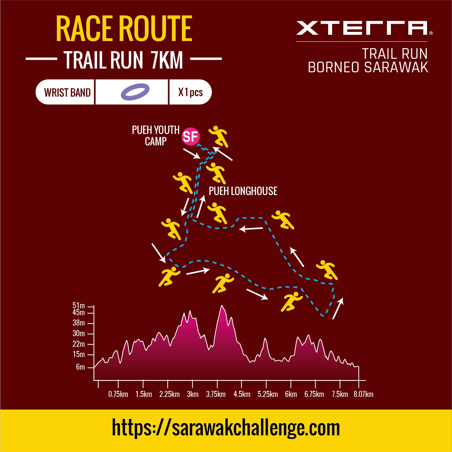
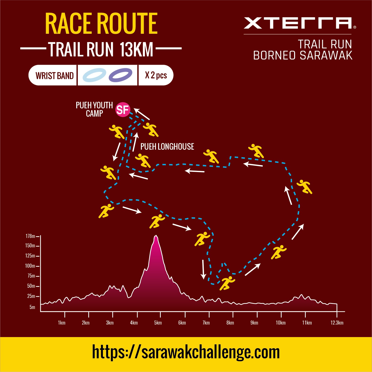
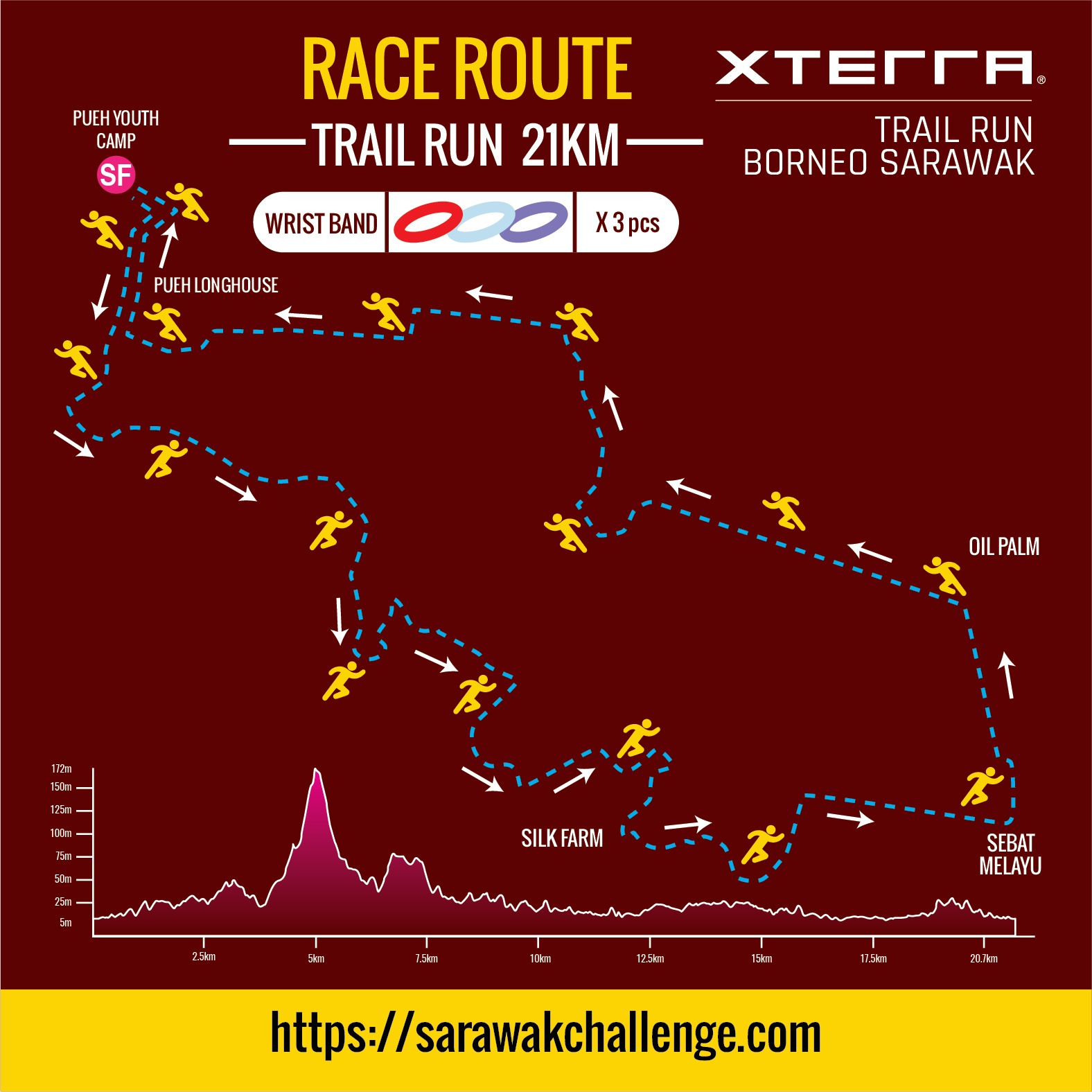
Trail Run Section
Note, that the running trails will cross the main road and caution is required. There will be marshals, however runners are be required to be vigilant when on the road. As always, major junctions and deviations will be marked and marshalled but runners are expected to be observant and follow the signs and the red and white trail marking tape. The trails also pass through forest trails where attention needs to be paid to the terrain underfoot. As we are passing through community lands, we are provided access thanks to the community. Be courteous and respectful at all times.7 km
After crossing the road, the trail passes through local orchards and forest crossing a stream and then continuing until a small local access road is reached. The trail continues along this access road until then re-enters the forest via a local trail. Passing through local orchards and crossing a stream, this trail climbs a hill until an access road is reached. The 7 km trail splits off and returns down the access road to a local road. Follow the signs as the trail continues along the road and then crosses over to a small road that follows a bund. Continue along this road until a small village bridge and cross over into the village. There will be a check point and the trail re-enters the forest and then returns towards the start / finish re-crossing the main road.The 7 km trail run will have 1 checkpoint and 1 water station.
13 km (for both Saturday and Sunday)
After crossing the road, the trail passes through local orchards and forest crossing a stream and then continuing until a small local access road is reached. The trail continues along this access road until then re-enters the forest via a local trail. Passing through local orchards and crossing a stream, this trail climbs a hill until an access road is reached. The 13 km trail continues up the access road passing through a local plantation before reaching a waterfall. Caution is required as the trail cuts across the stream and the boulders can be slippery. The trail then winds up along a jungle path climbing to the highest point of the trail. Once the apex of the climb is reached the descent is along a ridge line that leads down to a farm and then crosses into an open plantation. From this open area, the 13 km trail splits to the left following a track that leads to an orchard and through a village. After the village, there is a right turn along a local road and another left turn onto a smaller road. As the trail continues the road narrows until and access road is reached. Follow the signs as the trail heads back to then through the paddy fields until a small local bridge is reached. Cross over into the village. There will be a check point and the trail re-enters the forest and then returns towards the start / finish re-crossing the main road.The 13 km trail run will have 2 checkpoints and 2 water stations.
21 km
After crossing the road, the trail passes through local orchards and forest crossing a stream and then continuing until a small local access road is reached. The trail continues along this access road until then re-enters the forest via a local trail. Passing through local orchards and crossing a stream, this trail climbs a hill until an access road is reached. The 21 km trail continues up the access road passing through a local plantation before reaching a waterfall. Caution is required as the trail cuts across the stream and the boulders can be slippery. The trail then winds up along a jungle path climbing to the highest point of the trail. Once the apex of the climb is reached the descent is along a ridge line that leads down to a farm and then crosses into an open plantation. The 21 km trail continues through the plantation crossing a newly constructed bridge and then ascending along a project site road. From the project road, follow the markings as the trail leads down a ridge line to a forest covered ridge and through a local plantation and orchard. The trail will then pass a beautiful water fall and continue along a forest covered trail to a small village road. There will be a section along a local road to access a plantation road. The plantation road will lead back to small bridge and then through a local plantation emerging on an access road. Follow the signs as the trail heads back to then through the paddy fields until a small local bridge is reached. Cross over into the village. There will be a check point and the trail re-enters the forest and then returns towards the start / finish re-crossing the main road.The 21 km trail run will have 3 checkpoints and 3 water stations.